


 My Account
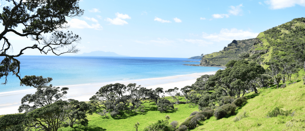


Profile
How to get to Pakiri
Take State Highway 1 north to Orewa. Follow directions to Whangarei. Continue up SH1 to Warkworth where you turn right at the lights and follow signs to Leigh and Goat Island Marine Reserve. Go past the Goat Island Marine Reserve turn off and continue over the hill.
History
The council purchased 172 hectares of land at Pakiri for regional park purposes in 2005, and in 2010, acquired an additional 7.2 hectares of land adjoining the regional park. The park land has almost a kilometre of sandy, coastal foreshore along Pakiri beach. The park land is a combination of steep coastal terrain, with a shoreline dominated by creeping sand dunes with some flat grassland.
The elevated hinterland offers spectacular panoramic views along the extensive Pakiri coastline and over the northern Hauraki Gulf.
Part of the land that was purchased, known as the Arrigato Block, is subject to a resource consent that imposed conditions relating to the revegetation of parts of the land.
Approximately half the land is grazed pasture. The coastal dunes contain stands of mature pohutukawa trees and parts of the steep coastal terrain are being planted with native vegetation to stabilise the land. The land contains the only mainland protected population of sand tussock in Auckland region and a series of perched freshwater wetlands.
Dotterels and fairy terns nest on the adjoining beaches. The beach and dunes are of regional geological significance, and Pakiri beach contains excellent examples of active dune features at the southernmost end of the beach. Pakiri beach is the longest sandy beach in Rodney Ecological District.
Pakiri park land is within the rohe of Ngāti Manuhiri, who claim whakapapa connections to Tahuhu, Haumoewharangi, and Ngawhetu, Maki and the Waiohua and Tainui (Hauraki-Waikato) peoples. Pakiri is adjacent to Te Taumata, an Ngāti Manuhiri reservation (current Māori freehold land) and has coastal papakainga and pa of significance to tangata whenua; these include Pito Kuku, Te Kiri and Okakari pa.
Limited evidence of European settlement dating from the late 1850s exists in the form of introduced tree species, such as macrocarpa and fig. The park land was the location of the house of William Medlands c. 1859, an early settler in the area.
See more about dog walking restrictions, tracks, park facilities and activities at regionalparks.aucklandcouncil.govt.nz/pakiri
Map
Sorry, no records were found. Please adjust your search criteria and try again.
Sorry, unable to load the Maps API.


Comments
You must be signed in to leave a comment